Expected hurricane could have local impacts next week
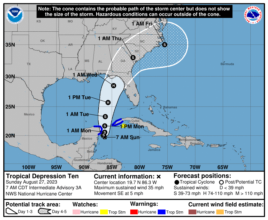
Tropical Depression 10, which formed in the Caribbean over the weekend, is forecast to become a tropical storm, then a hurricane over the next few days as it makes its way towards Florida’s northwest coast.
Most forecast models show the storm is anticipated to make landfall near the Big Bend region, though direct impacts to Gulf County and surrounding areas are possible at this time.
Residents in the area are advised to closely monitor forecasts and review their hurricane preparedness plans.
On Saturday, Gov. Ron DeSantis issued a state of emergency for 33 Florida counties to prepare for the potential storm, including Gulf, Franklin and Bay Counties.
As Florida enters the busiest part of the Atlantic hurricane season, which runs June 1 to Nov. 30, the second tax-free holiday of the year began Aug. 26 and runs through Sept. 8. Common household items found in a hurricane kit are exempt from sales tax during the two-week period. The tax holidays also include some items related to the safe evacuation of household pets.
At 8 a.m. Sunday, the center of Tropical Depression Ten was about 70 miles southeast of Cozumel, Mexico, moving toward the southeast near 5 mph, and it is likely to meander near the Yucatan Channel through early Monday. A faster motion toward the north or north-northeast was expected later on Monday, bringing the system over the eastern Gulf of Mexico.
The storm is expected to produce three to six inches of rain in areas along the Florida panhandle, with isolated higher totals of 10 inches. Winds in the area are expected to reach upwards of 50 miles per hour.
For instructions on how to remain hurricane prepared, visit https://www.stateofflorida.com/articles/hurricane-preparedness-guide/#:~:text=Make%20sure%20all%20trees%20and,secure%20and%20brace%20internal%20doors.


